Live Project Updates
- Plumpton Road is partially open, with one lane closed. STOP/GO traffic controls are in place. Be prepared to stop, follow directions and stay alert for workers and hazards.
- Access to the Wagga Wagga Country Club remains open.
- The Plumpton Road Pathway is closed between Nelson Drive and Lansdowne Avenue. Pedestrians and cyclists are advised to use alternative routes.
Road users and residents can also stay up to date via www.livetraffic.com.
Overview
To support development of the Southern Growth Area between Lake Albert, Springvale and Rowan, Plumpton Road will undergo a major upgrade, alongside broader improvements to key surrounding infrastructure.
The upgrades will relieve congestion and improve safety on Plumpton Road, enhance local stormwater management, and upgrade pedestrian and cyclist infrastructure, ensuring the corridor is well equipped to accommodate future population growth.
Once complete, the enhanced corridor will serve as a key southern gateway, playing a major role in Wagga Wagga’s future growth as a thriving inland city.
This project is scheduled for delivery during 2026 and 2027, weather conditions and contractor availability permitting.
Benefits
Key benefits of the project include:
- A modern, urbanised road corridor designed to sustainably handle the city's growth.
- Improvements to road layout, surface and traffic flow to ensure smoother, safer travel.
- Safety-driven upgrades to pedestrian and cyclist infrastructure.
- Upgraded stormwater infrastructure with expanded water drainage capacity.
- New trunk sewer and potable water infrastructure to future-proof capacity.
Design
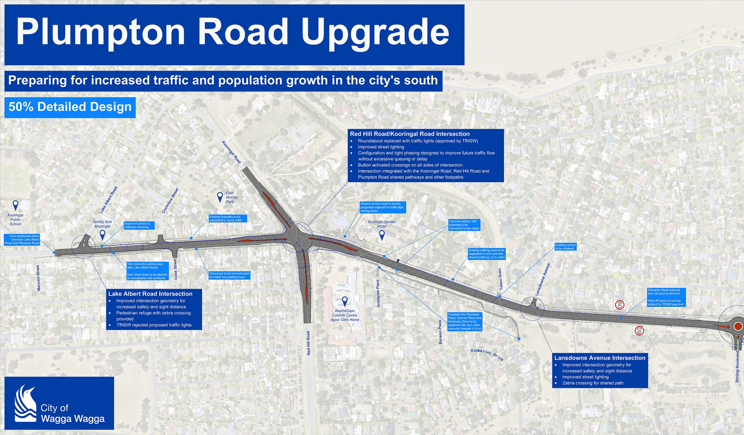
Disclaimer: The detailed design for the Plumpton Road Upgrade remains under development. This graphic illustrates the current scope, configuration, and overall design intent; however, all elements are subject to change as the design process progresses.
Plumpton Road will be duplicated to four (4) undivided lanes between Lake Albert Road and Lloyd Road intersections.
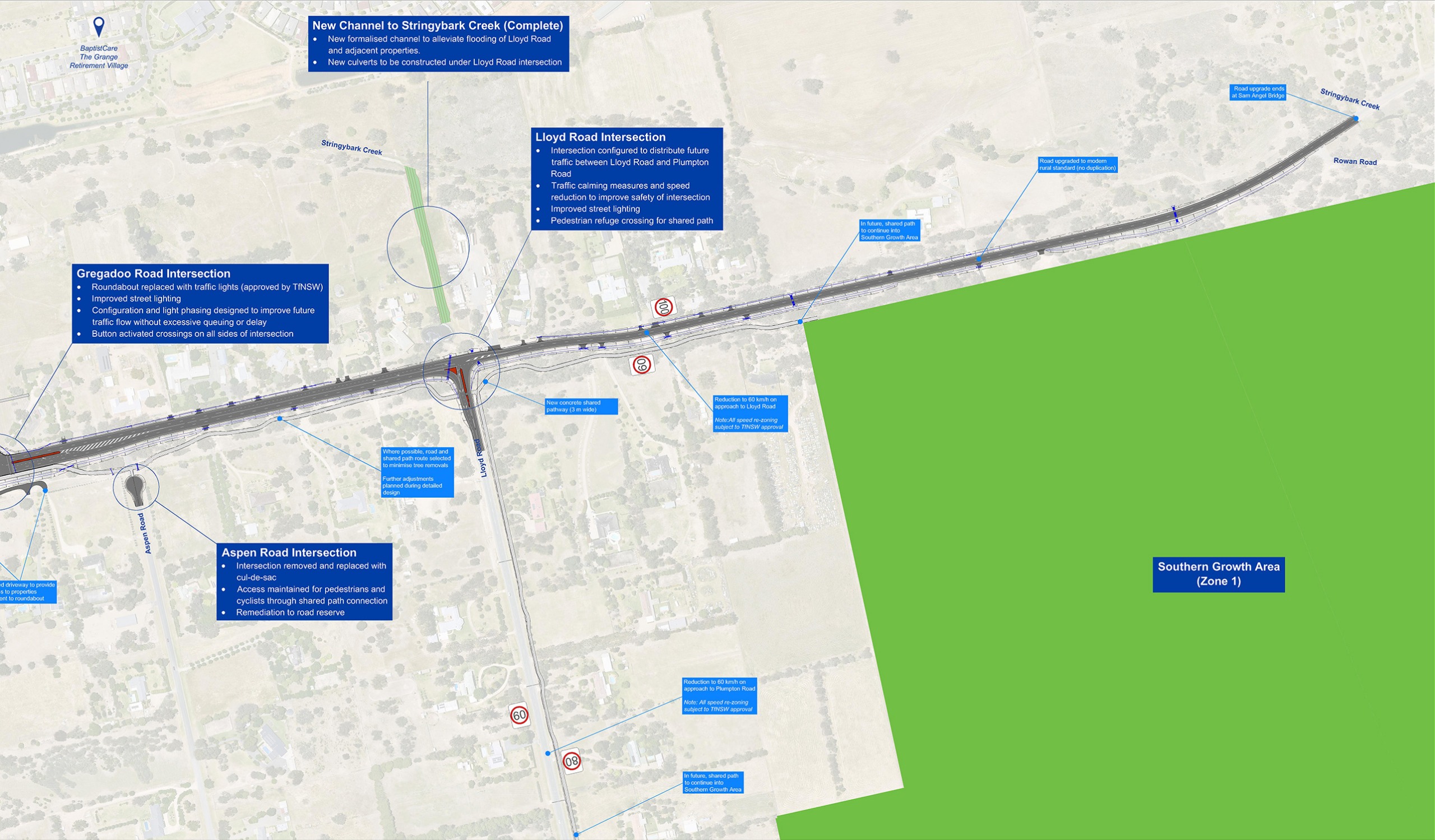
Upgrades to Plumpton Road, south of Lloyd Road, as far as Rowan Road, will maintain the road as two lanes.
Lake Albert Road
Intersection realignment closer to 90-degrees, improved street lighting, and a new pedestrian “zebra” crossing. An application for traffic lights was declined by Transport for NSW.
Red Hill Road / Kooringal Road
TfNSW approved installation of traffic lights, with suitably configured turning lanes and pedestrian‑activated crossings, along with improved street lighting.
Lansdowne Avenue
Upgraded intersection with a new pedestrian “zebra” crossing, improved street lighting, and enhanced sight lines.
Stirling Boulevard
Construction of a dual‑lane roundabout with pedestrian refuge islands on all approaches and improved street lighting.
Brindabella Drive
Upgraded intersection with improved street lighting and sight lines.
Nelson Drive
Upgraded intersection with a new pedestrian “zebra” crossing and improved street lighting.
Springvale Drive
Upgraded intersection with improved street lighting and sight lines.
Gregadoo Road
Approved installation of traffic lights and pedestrian‑activated crossings, plus improved street lighting and sight lines.
Aspen Road
Closure at Plumpton Road to create a cul‑de‑sac, following resident consultation, to improve safety and road network efficiency. Further information is available here.
Lloyd Road
New channelised intersection with a dedicated right‑turn lane into Lloyd Road and an acceleration lane for left turns out onto Plumpton Road.
Other Intersections
No changes proposed at Cochrane Street, Cook Street, or Rowan Road, aside from minor maintenance works.
Subject to assessment and approval by Transport for NSW, it is proposed that the speed limit between Lake Albert Road and Lloyd Road, including part of Lloyd Road leading into Plumpton Road, be adjusted to 60 km/h. All other speed limits are proposed to remain unchanged.
The existing walking track along the eastern side of Plumpton Road will be upgraded to a three (3) metre wide concrete path, shared between cyclists and pedestrians. The shared path will extend south towards Rowan, heading down both Lloyd Road and Plumpton Road. In future, this shared path will connect into the Southern Growth Area (SGA).
A new wider footpath (1.5 metres) will be installed on the western side of Plumpton Road leading from the new traffic lights at Red Hill Road connecting into Grampian Place, Barwon Place and Kimberley Drive. This path is designed to create convenient pedestrian access from these areas of Tatton onto Plumpton Road.
A new footpath (1.5 metres) will be installed on the western side of Plumpton Road, from Stirling Boulevard to Springvale Drive. Pedestrian refuge crossings will be provided near Springvale Drive and Stirling Boulevard to connect this path into the wider network.
Between Lake Albert Road and Nelson Drive, Plumpton Road will be upgraded to urban kerb and gutter style drainage.
South of Nelson Drive, Plumpton Road will be upgraded to a semi-urban drainage standard with formed grassed swale drains adjacent to the road and some sections of kerb and gutter.
Works will be completed to upsize the culverts under Plumpton Road at the Stringybark Creek Diversion Channel, south of Nelson Drive, to alleviate flooding in larger rain events.
A large stormwater channel has also been completed between Lloyd Road and Stringybark Creek to alleviate flooding in larger rain events.
On-street concrete parking bays will be constructed on Plumpton Road between Lake Albert Road and Red Hill Road intersection to allow for road widening. These will be similar to the existing parking bays on Lake Albert Road. No property acquisition will be required.
As required, driveways will be reconstructed to connect with the new road. Driveways will be constructed to the same width and material as existing, or to the Council standard, whichever is greater.
Alignment for road, footpaths and services will be carefully selected during detailed design to avoid any unnecessary removal of trees and in accordance with the requirements of the REF (Review of Environmental Factors). Any street trees removed will be replaced with new plantings in accordance with the Street Tree Policy.
Road Works and Detours
Road users and residents will be kept informed of traffic disruptions through on‑site Variable Message Signs (VMS) and via www.livetraffic.com.
Where possible, advance notice of upcoming traffic impacts will be provided through Council News and regular updates to this webpage.
Council will work proactively and well in advance with key stakeholders, transport operators, and relevant agencies to plan, coordinate, and clearly communicate major road disruptions and detours.
Council will also work collaboratively with nearby businesses, providing timely and consistent information to help share road updates and manage impacts during construction.
Contractor — Huon
Following a competitive tender process, Huon Contractors Pty Ltd (Huon) was awarded the Design and Construct contract for the Plumpton Road Upgrade in October 2025. Under this contract, Huon is responsible for completing the full engineering design and delivering all subsequent construction works. For more information, please refer to the Council News article.
Huon is a civil engineering construction company specialising in road, bridge, and subdivision works across the ACT and NSW. Huon has previously been engaged by Council to deliver several major projects, including the Riverina Intermodal Freight and Logistics (RiFL) Hub, the Old Narrandera Road Upgrade, and the Riverside Redevelopment (Stage 2).
Council will maintain overall governance of the project, providing ongoing oversight of both the works and Huon Contractors through to successful completion.
Funding
This project is proudly funded by the NSW Government via the Accelerated Infrastructure Fund (AIF) Round 3, in association with Wagga Wagga City Council.
![]()


