Overview
The Active Travel Plan (ATP) is a large network of dedicated shared paths which, when complete, will connect the suburbs of Wagga Wagga and provide residents with a safe, alternative transport option for commuting.
The Active Travel Plan Stages 1 and 2 has 13 shared bicycle and pedestrian path links. The project commenced in 2018 starting with planning, budgeting and design work, with construction commencing in mid-2019.
A significant portion of project has been completed. However, due to complexities of the project there are delays in the construction of some sections of the ATP such as the Forest Hill link.
The below map shows the locations of the ATP links.
Green = sections and links completed and open for public use.
Orange = sections and links that are open for use, but awaiting completion.
Red = planned sections and links not yet underway.
Links open for use
The Eastern Levee Link is located along the eastern bank of the Murrumbidgee River from the Wiradjuri Bridge in the CBD, to the Sturt Highway in East Wagga Wagga.
The Eastern Levee Link is open for public use.

The Faye Ave Link connects streets in Kooringal to the Active Travel Network. It is located between Lake Albert Road to Kooringal Road.
The Faye Ave Link is open for public use.

The Kapooka Link connects Kapooka to Glenfield Park, Ashmont and Mount Austin via Fernleigh Road, through Silvalite, under the Olympic Highway and into Kapooka.
The Kapooka Link is open for public use.

*map is approximate only, trail may differ slightly to diagram.
The Kooringal Link of the Active Travel Network starts at Hammond Ave, meeting up with the Eastern Levee Link, then runs down Kooringal Road until it turns down Lake Albert Road and connects to the Lake Albert Link.
The Kooringal Link is open for public use.

The Lake Albert Link is a complete circuit of Lake Albert with additional paths linking nearby streets.
It connects with the Kooringal Link at the northern end of the lake.
The Lake Albert Link is open for public use.

The Morgan Link is located on Morgan Street, starting on Day Street at the Eastern Levee link, passing through the CBD, and meets with the Central Link on Murray Street.
A section in the middle of the Morgan Link is not suitable for bicycles (shown with the gap in the link below).

The Pomingalarna Link connects the Kapooka Link at
Silvalite to Bagley Drive where the Pomingalarna Multisport Cycling Complex is located.
The Pomingalarna Link is open for public use.

The Red Hill Road Link is located along Red Hill Road in Wagga Wagga's Southern suburbs.
It connects the Kooringal Link at the intersection of Kooringal and Lake Albert Roads, to the Kapooka Link near Glenfield Park.
The Red Hill Road Link is open for public use.

The University Link connects the CBD to the northern suburbs of North Wagga, Estella and Boorooma.
The University Link is open for public use.

Links in progress
The Bourke Link, once completed, will connect with the Central Link at Kildare Street, passing through Turvey Park, down Fernleigh Road, then down Bourke Street to the Southern Suburbs of Lloyd and Bourkelands.
Currently there are sections that are open for public use, this includes the section from Kildare Street to Fernleigh Road, and south of Red Hill Road.
The remaining sections (in orange) are awaiting completion.

The Central Link, once completed, will run from the Eastern Levee Link at Fitzmaurice Street, around along Beckwith Street and Murray Street, meeting up with the Bourke Link on Brookong Ave.
Currently the Travers Street section (in green) is open for use.
From The Esplanade to Brookong Ave is awaiting completion.
The Beckwith Street section of the link is planned but not yet underway.

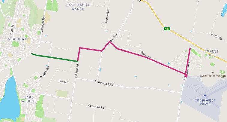
The Forest Hill Link, when completed, will connect the suburb of Forest Hill to Kooringal Road.
The following is the proposed route and is not yet available for public use.

The Wollundry Link, located in the Wagga Wagga CBD and connects the Eastern Levee link on the east shore of the Murrumbidgee River, to the Central Link on Beckwith Street. The Wollundry Link runs through the Wollundry Lagoon Precinct.
It is planned but not yet completed. Walking paths are present through the precinct, but are not yet suitable for bicycles.

Planned Links
The Hammond Ave Link, once completed, will start at the entry to the Equex Centre on Copland Street, around along Kooringal Road to Hammond Ave (Sturt Highway).


